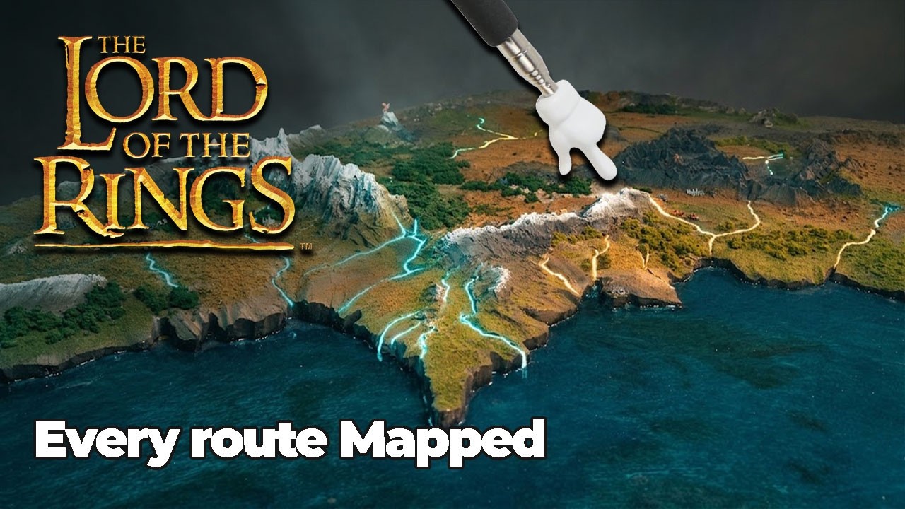
Christopher Claflin built a giant miniature map of Middle Earth, and the moment you see the river Anduin flowing all the way from the lake near Lothlórien down through Gondor to Osgiliath, Boromir’s funeral suddenly becomes something else entirely. Geography has always been the quiet engine running underneath Tolkien’s story, but most viewers watch three films without ever seeing how the pieces connect spatially. This map, built to match the official cartography prepared for the films, makes those connections visible in a single glance.
How the map came together
Claflin started by placing a sheet of foam in front of a projector, traced the official film map onto the surface, cut it out, and then built up mountain ranges, forests, and broader geographic landscapes by hand. Middle Earth covers roughly 1.5 million square miles, a landmass a little under half the size of the United States, so the landmarks like the Black Gate, Mount Doom, and Barad-dur are not true to scale. As Claflin put it plainly, ‘if the landmarks were true to scale, you wouldn’t be able to see them with a naked eye.’ Cities on the map follow the same logic Tolkien himself used in Bilbo’s maps and Faramir’s map in the Return of the King: correct location, illustrative scale.
The fellowship’s departure from Rivendell heads south along the Misty Mountains toward the gap of Rohan. At the peak known as Caradhras, the Red Horn, Claflin points out a detail easy to miss on screen: Saruman’s voice is waking the mountain while Gandalf tries to lull it back to sleep. The map makes the push-and-pull of that scene legible from above.
The geography nobody talks about
The breaking of the fellowship at the western shores of lake Nen Hithoel opens one of the map’s richest geographic payoffs. When Aragorn places Boromir’s body in a canoe and sends it over the Falls of Rauros, he is sending him south along the river Anduin, which flows all the way into Gondor beside Osgiliath and Minas Tirith. That is why Faramir is the one who finds Boromir’s broken horn. Aragorn sent him home.
Elsewhere, the map resolves questions the films raise but never answer. The 500 elves who arrive at Helm’s Deep travel south from Lothlórien. Theodén’s line ‘where was Gondor when the Westfold fell’ refers to the specific western half of Rohan, the region running right up to Isengard’s border. And the journey from Minas Tirith to the Black Gate that feels like a cut in the film is actually a week-long, 120 to 150 mile march through Osgiliath and the crossroads of Ithilien. That march itself, not the battle, is what draws Sauron’s forces north and clears the plains of Gorgoroth for Frodo and Sam.
To demonstrate the scale of Helm’s Deep, Claflin laid out 500 elf figures, 300 men of Rohan, the three hunters, and 10,000 Uruk-hai on a physical model of the fortress. Each Uruk-hai figure is smaller than a grain of rice.
A small burial mound near the Fords of Isen
On the edge of the plains of Rohan, where the Fords of Isen run, Claflin placed a small burial mound with flowers on it, marking the spot where Théodred dies in the books.
The four hobbits’ return journey from Minas Tirith covers more than 1,200 miles, looping back through Rohan, up to Rivendell, and finally home to the Shire, before the Grey Havens farewell that ends the trilogy. Seen from above on the map, that final arc traces nearly the full width of Middle Earth, east to west, one last time.
 Wake up to Only Happy News!